Cinderloo 1821 has used maps and mapping as a fundamental way of exploring the Cinderloo story and engaging people. The protesting miners of 1821 came from many communities within the area that has become the town of Telford so plotting the route of the protest and the communities that were involved has been at the heart of many of our activities.
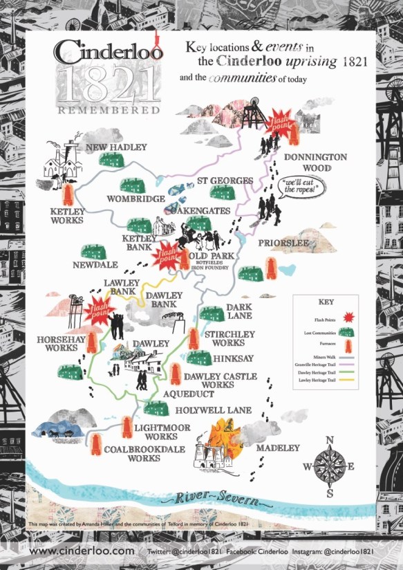
Illustrated Cinderloo Map
Amanda Hillier produced an illustrated map of the route, using images and work produced in a number of community workshops co-led with Andrew Howe throughout 2019. A special edition of A3 print copies of the map can be ordered for £5 +P+P by emailing us.
Story Map
The illustrated map and a number of other images and video are now incorporated into an interactive map telling how the story unfolded. This Storymap created with the assistance of Ben Proctor can be found by clicking the image below:

Dawley Pubs
Local historian, Malcolm Peel, has researched the history of public houses in the Great Dawley area. Pubs would have been one of the few public locations for miners and other workers to meet in 1821 and, perhaps, this is where they made plans for the Uprising. The number of pubs rose from around 10 at the time of Cinderloo to over 40 in the 19th Century before falling again to around 10 at the present time.
Click on the image below to explore the Dawley pub crawl:

Get Involved
We are aiming to add to our collection of maps showing routes of heritage walks, and plotting other features of historical interest relating to Cinderloo and the landscape. We will also continue to develop these existing maps by adding images, artwork, factual information and personal stories relating to the places shown. If you have suitable material you would like us to include, or ideas for new maps to create showing other layers to the story then please get in contact.
Map is both noun and verb, a functional record and its process of creation. A map is a representation that is not static but dynamic, and it may be a physical material or digital and interactive.
The map may be a diagram or collection of data showing the spatial arrangement or distribution of something over an area or a defined physical or conceptual space. Databases can hold multiple viewpoints and interpretations.
A map is not objective but subjective, always dependent on the map maker. So what is left out may be as significant as what is included.
